Fault Line

Hike Date: October 27-29, 2018
Trail: Superior Hiking Trail
Trip Plan: Backpack in to Fault Line Creek campsite, set up for two nights. Then trail run/hike 45 miles at 4 miles per hour.
Day 1 – Backpack in ~4 miles from County Road 4/Beaver Bay trailhead to Fault Line Creek campsite. Set up my tent, and run south for 16 miles/2 hours out and back.
Day 2 – Run north for 3 hours out and back, 6 hours total for hopefully 24 miles.
Day 3 – Backpack back out to the trailhead.
Backpack miles: 7.5 miles, Running miles: 38.5 miles
Trip Synopsis:
Day 1 – Saturday, October 27, 2018:
Garmin Data (hike in):
I started the day a bit late due to a race timing gig earlier in the day. Emily and I went for breakfast and I loaded up on calories, but didn’t make it onto Highway 61 until well after noon. I parked at Lax Lake Road right outside of Beaver Bay, solo and in a cloud of mist. It looked like it could rain at any moment. I heaved the huge backpack onto my shoulders, grabbed a bag of beer in one hand and a gallon of water in my other hand.
Oof, my shoulders were instantly pained. I was used to walking between 15 and 20 minutes per mile with the dogs in training and the first mile was a struggle and over 20 minutes. I was anxious to get to camp quickly because I knew I wanted to get as close to 20 miles in as possible with the fast pack right after setting up my tent. I did some quick math–I could do two hours out and back and if I stick 4 miles per hour that makes 16 miles. Then I can do 24 miles tomorrow, plus the 4 miles that I was hiking at the moment almost adds up to my goal mileage of 45. It was around 2:30pm at this point, if I could get the fast pack on and get out to the trail by 3:30pm, I’d be back to camp for the night by 7:30pm. It started getting dark at around 6pm… I’d be running in the dark for sure.
The trail was slick, a lot of rocks were exposed in this section and it made for even slower walking. I thought about biffing it with the huge pack on… it must have weighed at least 50 pounds as I was planning on setting up camp for two nights and camping nicely. Luckily I did not go down. My hips hurt from the waist belt, my shoulders only got more pained and I started to feel like a wuss. Sheesh, I should practice backpacking more, I thought! That makes you real rugged and tough. Mentally, too. But today, I was practicing fast and light at 4mph on the dot.
The Fault Line Creek campsite was right around the corner, and I knew because of the ridiculously rocky section right alongside the beaver pond upon which my campsite was situated. I finally got there and was very relieved to take the pack off. I quickly set up camp and got everything organized in a way that would make my life in the dark easier. I pre-packed the fast pack and hit it as soon as possible.
Garmin data (run):
With trekking poles in hand, hydration pack on my back, I was ready to roll. I set out southbound from Fault Line Creek campsite towards the Split Rock River. I didn’t know exactly how far I’d make it, but knew there were several spur trails and loops and such in the Split Rock River section and could probably tack on some segments to get to two hours, then turn around. I found it hard to run right out of the gate. It was a bit muddy, really rocky, and all of the rocks were really slippery.
I’d purchased a new pack and was excited to try it out. It’s the Ultimate Direction Jurek FKT vest, aptly named for my purposes. I was excited to test a pack with front holders for water. My “old” fast pack/hydration pack has no pockets or anything on the front, which means everything is the back. I don’t mind having a hydration bladder in the back, but nixed that today in lieu of the two front water bottles that came with the vest. The first few miles with it felt awesome. I was cruising, right on pace despite the challenging conditions. But that is just the Superior Hiking Trail… it’s not easy no matter what. The weather was holding–no rain but definitely cloudy. I expected rain, especially overnight and early Sunday morning. Given the recent wet weather, the trail was in pretty dang good shape, actually. I had a bit of a time buffer and decided to power hike along the Merrill Grade to see if I could haul ass near 15 minutes per mile on a flat, non-rocky section.
Miles were clicking off but time seemed to be moving a little bit slow as I could sense dusk settling in. I was not looking forward to running in the dark. I climbed to a ridgeline with a great view of Split Rock Lighthouse and some cool rock formations near the mouth of the Split Rock River and figured I’d get pretty close to the Split Rock River itself. I decided I’d just take the regular SHT route to the bridge crossing, which was out at the moment. Maybe I could scope out the former bridge location… maybe I could cross it my rock-hopping, I thought. To try as hard as possible to get to exactly 8 miles at exactly 2 hours, I was cruising and running pretty hard once I entered the State Park. I got to exactly 2 hours in between the two East Split Rock River campsites, somewhere around 7.95 miles. Perfect.
My goal for the return trip was to perfectly even-split the trek and feel good. At this point, I was running up out of the river valley as darkness was beginning to wash over the entire landscape. I hadn’t seen anyone all afternoon at all. My body was holding up really well with a healthy combination of hiking and running. I was definitely frustrated about the slippery conditions but in reality there was really not too much to be frustrated about. I was out here in the woods, three days to explore and spend time on the trails, feeling good.
I ran Merrill Grade on the way back. Midway through, I ate some food and put my waist light and headlamp on. Darkness seems to come so quick… all the sudden BOOM! You can’t see a thing! In that time between dusk and total darkness, albeit a brief time, it seems like you need a headlamp but it almost does more bad than good for actually seeing the ground. 5 more minutes and it was dark.
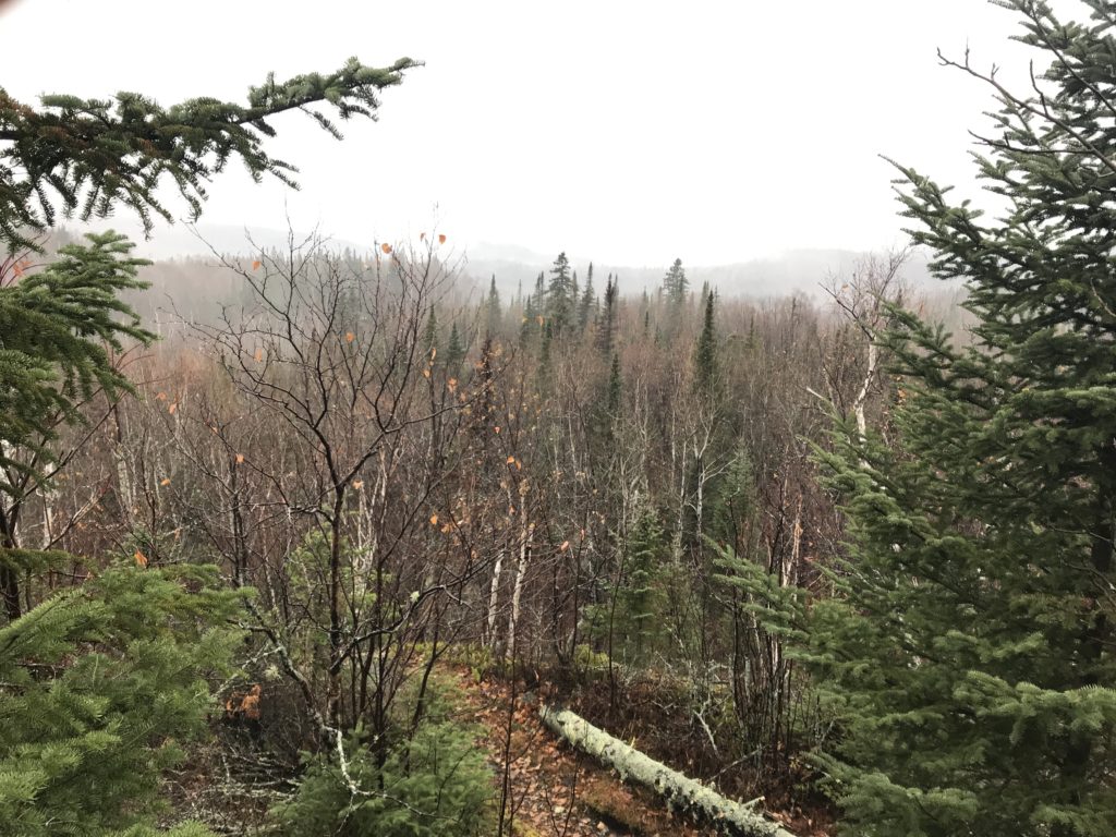
I felt myself slow down in the dark but tried to keep moving. I didn’t want to slip on the steep downhill rock faces, that would really mess up my whole trip! It was kind of creepy in the dark. Halloween weekend, dreary and misty and cloudy, and the section leading into Fault Line Creek campsite was full of small black spruce and other coniferous trees and thousands of birch. Some of those birch trees can play tricks on your eyes and mind in the dark. They look like faces, like people, like monsters.
The trail became notably more technical and challenging with one mile to go left to camp. I didn’t necessarily feel tired or hungry so gave up on my quest for an even 4 hour/16 mile trip and started looking for good firewood. I collected some birch bark and found a few sticks. After carrying those around a bit, I realized that it was kind of stupid… I might as well get back to camp and search from there. I’d left a trail of brittle birch bark along the trail just because I couldn’t carry it all and said to myself “forget it”, hurled it all into the woods along with my stick. I got to camp, stopped my watch, took off the pack and began to multitask.
I got my water boiling, gathered some fresh birch bark (which was everywhere) and some damp sticks. I was lucky enough to find some premium firewood, but everything was damp. I cooked my dinner, got a fire going, gathered some more wood, and soon enough was eating next to a roaring fire with a beer in hand. Nice.
Day 2:
Garmin Data:
I wanted to hit the trail at 8am sharp. Without setting an alarm, I was shocked to check my phone and see 7:35am. After a restless night of sleep and rain, I felt like I finally fell into a deep sleep in the dawn hours. I jolted up and started to prepare for a 6 hour day on the trail. I began to multitask–boil water, cordon off my breakfast of coffee and oatmeal from the rest of the junk strewn about my tent, wipe off the excess moisture seeping in from everywhere, put on my running shorts, shove essential items into my running pack, pour boiling water into my camp french press, begin cooking the oatmeal. I made a trip to the latrine, ate quickly and was off on the trail right after 8am. I was impressed by my efficiency, but felt rushed all the same. It had rained for hours the night before, seemed to have mostly stopped, yet was very misty. It seemed like regular raindrops had split into 1,000 tiny raindrops and didn’t have enough weight to completely fall to the ground and so were suspended in the air. Heading north today, I made it around the beaver pond and spotted my tent from a couple hundred feet away. I warned the beavers to not mess with my shit while I was away.
I got to the top of the fault line ridge and was glad I brought my camera along for pictures. Before long, I was back to my car. There was one other vehicle in the parking lot on this overcast, crummy day. I wondered if anyone else was on the trail… It was the last weekend before rifle hunting season for deer began, so perhaps there were others like me trying to get one last backpack trip in before the deep winter set in. That didn’t look like the case, though.


Along Beaver River, it was just me and the roaring river. There was a huge yellow plastic divider thing pinned against some rocks and trees that caught my eye. No people at the sites, no people on the trail. Mud was at a minimum and I made it into the Silver Bay area without incident. I was munching on a caffeine Clif Bar and noted how the time seemed to be flying by today in contrast to yesterday’s tough hike into the night. I discovered a nice trick with my new pack to put my arm in the opposite shoulder strap and swing it around to my front to access the back compartments that were full of food.


I was making good time though Silver Bay, although this section seemed especially difficult. With last night’s rain, it was even more slippery on certain rocks with a light layer of moss on top. And in the cliffs above Silver Bay, there is a lot of slick rocks with a light layer of moss on top. But that also means no mud… so when I got to a section of non-muddy dirt trail, it felt so awesome. My feet seemed to slip out from under me with each foot strike.
Across Penn Boulevard, I checked my watch, checked the trail sign with upcoming landmarks and mileage, and I figured I could make it really close to Bean and Bear Lake… perhaps to the far trail register. I was hoping to get 12 miles in before the turnaround but knew a couple hours in that that wouldn’t happen. I was falling behind in the tough, wet conditions. I was running when I could, but it was really hard to find runnable sections! It seems like there were so many rocks… much more than I remembered. It’s always rockier and rootier than one can recall. However, the trail heading up to Bean and Bear is one of the most popular of the entire 310-mile Superior Hiking Trail and just as I’d hoped, it was well worn and seemed like a superhighway compared to the tight, technical, and obscenely rocky pieces of trail south of Beaver Bay. On the flip side, there were a few really serious mud pits. Knowing that I only had one pair of shoes for the whole weekend, I tried my best to avoid the mud, which slowed me down a lot. The worst part is that you can’t avoid it and my feet got drenched, my socks inundated with mud and water, and mud splashed continually onto my calves and shins.
Bean Lake was stunning as always, even in the dreary and cloudy conditions. I ran hard along the ridge, not taking a moment to dilly-dally to get as close to 12 miles as possible within my allotted 3 hours to head north before turning around. With one eye on my watch, I turned around a few paces before the far northern edge of Bear Lake right at 3:00:00. That was just over 11 miles. Not terrible…

On the way back, it was my goal to crush a few miles. Might as well push it, I thought. I really cruised through Bean Lake and down to Penn Creek and its campsite. I had seen a few people in this section, which wasn’t super surprising given its popularity. We were all lamenting over the mud, I’m sure. Time was moving quickly and before long I had made up some really good time back up along Silver Bay.

The rest of the trip was pretty low-key. I made good time and was focused. In a flash, I was back to my car. I stopped there, filled up my water bottles with water and picked up a banana. I made a plan to eat the banana at the “Fault Line Overlook”, which is a made up overlook with a distant view of Lake Superior and the end of the long beaver pond that my campsite was on.
It was slow going back to the overlook. I think the 11.3 mile section with Split Rock to the south and Beaver Bay to the north is perhaps overlooked as one of the toughest on the Superior Hiking Trail. It is just so rugged. The elevation isn’t super extreme but the rocks are. Soon enough, I made it to the overlook, less than a half mile back to camp. I’d lost some time on the last hour, but paused my watch and enjoyed the view of flat white. It’d really gotten foggy and I almost expected a downpour. You could feel the moisture in the air.
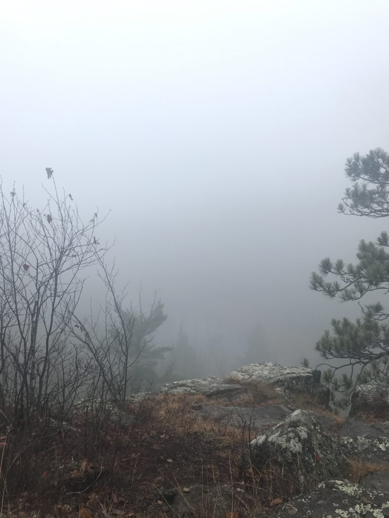
I ate my banana and started to get vertigo with the deep fog and haze. It was almost like a sensory deprivation or something… I didn’t spend a ton of time at the soggy and dank overlook and left right after my last bite of banana.
After getting back to camp, I tooled around a bit. I had recently adopted the campsite I was at, the Fault Line Creek campsite, and so wanted to do some maintenance. Well, there really wasn’t much to do and everything was wet anyways. My body felt great from the 20+ mile trek, which was very positive. I put on my rain gear and kept on the endless task of gathering firewood. Everything was damp, and I didn’t even need to lay a finger on a tree to know, I could see the drops of dew on every branch, leaf, and stick. Ugh.
Eventually, I gathered a bunch of quality firewood and stood it up next to the fire ring. I started looking for birch bark and was able to find some really good pieces deep in the woods. That stuff burns so well. After a few close calls of the fire burning out completely, I did get a good rager going. I enjoyed it for a while, and as I began preparing for dinner, a beautiful beam of sunshine hit the opposite side of the fault line’s bluff, illuminating a towering stand of bare birch trees. I looked up and was greeted to a small, small, tiny section of blue sky. It seemed that the soggy day was moving on.
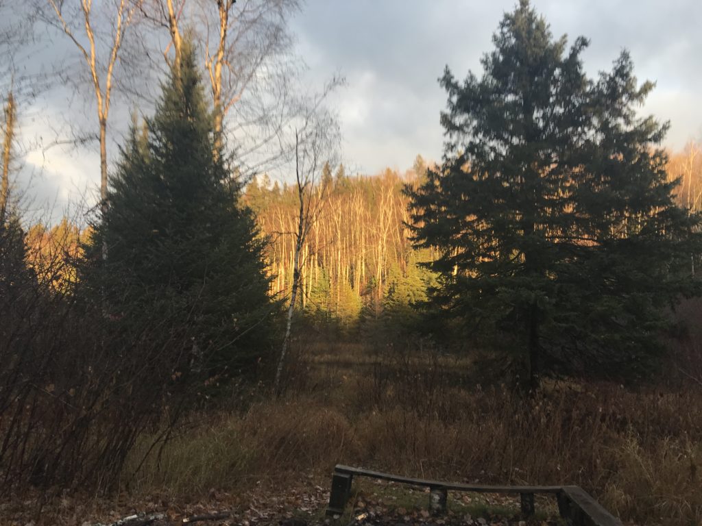


The clouds washed away. When the sun sank below the horizon and the blue turned to indigo and then to black, I was treated with a stunning panoramic view of the Milky Way. It was a great end to a tough day of dealing with the moisture.
Day 3 – Monday, October 29, 2018:
Garmin Data:
I woke up late to bright sunshine. It was great and very refreshing to see the sun. Also, it made cleaning up camp much easier. I dug out the fire pit, destroyed an “illegal” pit on a different part of the campsite, and took my time to make breakfast and pack up my campsite. Also, I did my strength workout on my camp pad in the open air, and that was really nice. Nice, and nice to get it out of the way… I definitely don’t think I would have done it at home!
The hike out was really nice. I had a chance to reflect on the weekend. Monday brought perfect weather, and I took the other part of the Cove Point Loop trail that I hadn’t been on this trip, including a half mile that I had never been on. It was a nice section of trail, and mentally easier since I had gone on the ~4 mile regular SHT section from my car to the campsite 3 times already on the weekend. My back and shoulders didn’t hurt nearly as much on the way out, but I had eaten and drunken quite a bit of weight! I certainly took my time hiking out, with no regrets whatsoever. Success on my first long trip of this training cycle leading up to a thru-hike in May 2019.
0 Comments